WMTS资源介绍
WMTS全称Web Map Tile Service,是允许用户访问切片地图(Tile Map)的一种服务标准。下面是一些常用的WMTS资源:
- http://gis.sinica.edu.tw/ccts/wmts/1.0.0/WMTSCapabilities.xml
由台湾中央研究院开发的中国历史地图- https://services.arcgisonline.com/arcgis/rest/services/NatGeo_World_Map/MapServer/WMTS/1.0.0/WMTSCapabilities.xml
National Geographic和Esri联合开发的包括行政边界,城市,保护区,高速公路,道路,铁路,水景,建筑物和地标等内容的地图 - https://services.arcgisonline.com/arcgis/rest/services/Demographics/USA_Population_Density/MapServer/WMTS/
美国人口密度图
- https://services.arcgisonline.com/arcgis/rest/services/NatGeo_World_Map/MapServer/WMTS/1.0.0/WMTSCapabilities.xml
- https://services.arcgisonline.com/arcgis/rest/services/USA_Topo_Maps/MapServer/WMTS/1.0.0/WMTSCapabilities.xml
美国地质调查局(USGS)纸质地形图的无缝扫描图像,展示了世界范围内的土地利用类型图,和美国详细的地形图(数字线划图形DLG) - https://services.arcgisonline.com/arcgis/rest/services/World_Imagery/MapServer/WMTS/1.0.0/WMTSCapabilities.xml
世界范围内的卫星地图,包含15米TerraColor影像、2.5米的SPOT影像、南极洲15米的Landsat影像。在美国大陆分辨率能达到0.3米,在西欧部分地图分辨率为0.6米。 - https://services.arcgisonline.com/arcgis/rest/services/World_Shaded_Relief/MapServer/WMTS/1.0.0/WMTSCapabilities.xml
以地形阴影表示高程的世界高程图。美国地区分辨率为30米,北纬60度到南纬56度之间区域分辨率为90米,在这个纬度范围之外的分辨率为1KM - https://services.arcgisonline.com/arcgis/rest/services/World_Street_Map/MapServer/WMTS/1.0.0/WMTSCapabilities.xml
世界范围内的公路/路网信息地图 - https://services.arcgisonline.com/arcgis/rest/services/World_Terrain_Base/MapServer/WMTS/1.0.0/WMTSCapabilities.xml
包含水深的、以地形阴影表示高程的地形图(世界范围内)
更多资源可以访问各大官网:
打开服务对应的链接(这是一个xml文件),可以看到文件结构如图1所示。
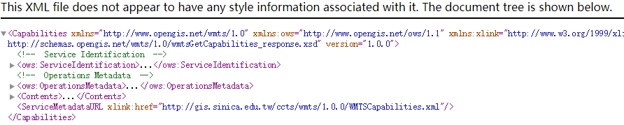
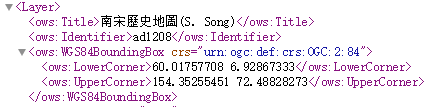
图层信息全都保存在<Contents>标签中,我们引用地图服务的引用信息就包含在这个标签内。<Contents>标签里面包含了<Layer>标签和<TileMatrixSet>标签,我们感兴趣的是前者。若该服务提供的图层数目较多,会存在多个<Layer>标签。在每个<Layer>标签中,包含了这个图层的Title和Identifier,如图2所示。一般来说,调用WMTS服务的某个图层,只需要声明该图层的Identifier即可。
Openlayer的WMTS解析器
Openlayers自带解析WMTS资源和创建WMTS图层的工具,引入这些工具的语句为:
1 | // WMTS loader |
创建解析器
1 | let parser = new WMTSCapabilities(); |
获取WMTS的数据
1 | let wmtsString = 'http://gis.sinica.edu.tw/ccts/wmts/1.0.0/WMTSCapabilities.xml'; |
解析数据并创建WMTS数据源
1 | let identifier = 'ad1208'; |
引用WMTS服务的MainMap.vue
MainMap.vue
1 | <template> |